Discover Toronto's history as told through its plaques
2004 - Now in our 14th Year - 2018
To see what's new on this site, you can visit the Home Page
Looking at this page on a smartphone?
For best viewing, hold your phone in Landscape mode (Horizontal)
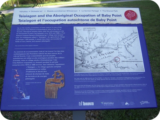
Teiaiagon and the Aboriginal Occupation of Baby Point
Photos by Alan L Brown - Posted August, 2011


This Story Circle, the eleventh of 13 story circles on the "Discovery Walks - The Shared Path", can be found on the path on the east side of the Humber River below Baby Point, almost a kilometre north of the Old Mill Bridge. Here's what the plaques say:
Coordinates: 43.652897 -79.501421 |
 |
Up on the nearby promontory of land is one of the best-known First Nations archaeological sites in the City of Toronto. Aboriginal peoples likely used this advantageous site for thousands of years, but between circa 1670 and 1688, a Five Nations Iroquois Seneca village was located here. Its inhabitants called it "Teiaiagon". An agricultural village of perhaps 1,000 people, it would have been surrounded by fields of corn, beans, and squash.
The Five Nations Iroquois established this and other communities along the north shore of Lake Ontario following their victory over the Huron-Wendat circa 1650. The strategic location of Teiaiagon remains obvious today. It was defended by the steep banks of the point, allowing its occupants to control the southern end of the Carrying Place trail, an important trade route linking Lake Ontario to the upper Great Lakes through Lake Simcoe.
We know of this village in part from Europeans who visited it. Father Louis Hennepin and 15 companions found refuge here in 1678 when their ship sought shelter from a storm. In 1680, the French explorer René-Robert Cavelier de La Salle recorded his stay at Teiaiagon while on his way north. The village was abandoned by the Seneca when they returned to their traditional homeland in what is now New York State. Later, the Mississaugas may have occupied the site as well.
The site of Teiaiagon was first investigated by archaeologists in the 1880s. Development of the area has consistently resulted in the discovery of artifacts and grave sites.
Shared Path Story Circles Information and Map
Discovery Walks - The Shared Path
Related webpages
The Humber River
Teiaiagon
archaeology
Five Nations Iroquois
Huron-Wendat
Carrying Place trail
Mississaugas of the New Credit First Nation
Related Toronto plaque
Baby Point
Related Ontario plaques
Louis Hennepin 1626-c.1705
La Salle at the Head of the Lake
Links to all the other Story Circles
#1 Discover the Humber River's Ancient Past
#2 Toronto Carrying Place
#3 Railways Over the Humber
#4 Roads over the Humber River
#5 Boating on the Humber River
#6-1 The Beginnings of French Toronto
#6-2 The Rousseaux Family and Early Toronto
#6-3 Jean-Baptiste Rousseaux 1758-1812
#7 Humber River Marshes and Oak Savannah
#8 Huron-Wendat Villages on the Humber River
#9 Hurricane Hazel
#10 The King's Mill
#12 Dundas Street Crossing and Lambton Mills
#13 Mississauga Settlements on the Humber River
Here are the visitors' comments for this page.
(none yet)
Here's where you can sent me a comment for this page.
Note: Your email address will be posted at the end of your comment so others can respond to you unless you request otherwise.
Note: Comments are moderated. Yours will appear on this page within 24 hours (usually much sooner).
Note: As soon as I have posted your comment, a reply to your email will be sent informing you.
To send me your comment, click [email protected].
Thanks
Webmaster
Note: If you wish to send me a personal email, click here.