Discover Toronto's history as told through its plaques
2004 - Now in our 13th Year - 2017
To see what's new on this site, you can visit the Home Page
Looking at this page on a smartphone?
For best viewing, hold your phone in Landscape mode (Horizontal)
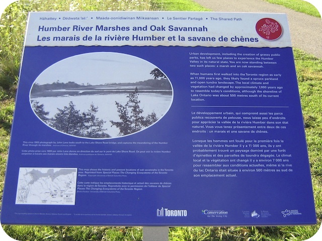
Humber River Marshes and Oak Savannah
Photos by Alan L Brown - Posted August, 2011


This Story Circle, the seventh of 13 story circles on the "Discovery Walks - The Shared Path", can be found along the path in South Humber Park on the west bank of the Humber River just north of the Queensway just as the path turns west. Here's what the plaques say:
Coordinates: 43.63659 -79.47885 |
 |
Urban development, including the creation of grassy public parks, has left us few places to experience the Humber Valley in its natural state. You are now standing between two such places: a marsh and an oak savannah.
When humans first walked into the Toronto region as early as 11,000 years ago, they likely found a spruce parkland and open tundra landscape. The local climate and vegetation had changed by approximately 7000 years ago to resemble today's conditions, although the shoreline of Lake Ontario was about 500 metres south of its current location.
The marsh at the mouth of the river was first formed perhaps 5,000 years ago, when the water level of Lake Ontario approached its current elevation, and the Humber River slowed here to meet it. The marsh's wide range of plants, fish, waterfowl, and mammals made it a vital seasonal hunting, fishing, and gathering site for Aboriginal peoples.
Further up this path, a black oak savannah is a rare remnant of an ecosystem that once flourished around the lower Humber River area on the dry, sandy soils of the bottom of former Lake Iroquois (which preceded Lake Ontario 12,000 years ago). Oak, white pine, and sassafras trees grew in small groups across a savannah of grasses and low shrubs. This vegetation was subject to frequent fires, helping to maintain the ecosystem.
Though significantly reduced in size and altered by both the loss of some species and the introduction of others, the remnants of both the marsh and the oak savannah have survived pollution, landfill, residential development, a previous golf course, and the construction of the adjacent Humber Wastewater Treatment Plant. Efforts continue towards the protection and regeneration of these remnant native ecosystems.
Shared Path Story Circles Information and Map
Discovery Walks - The Shared Path
Related webpages
The Humber River
marsh
oak savannah
oak
white pine
sassafras trees
Humber Wastewater Treatment Plant
Links to all the other Story Circles
#1 Discover the Humber River's Ancient Past
#2 Toronto Carrying Place
#3 Railways Over the Humber
#4 Roads over the Humber River
#5 Boating on the Humber River
#6-1 The Beginnings of French Toronto
#6-2 The Rousseaux Family and Early Toronto
#6-3 Jean-Baptiste Rousseaux 1758-1812
#8 Huron-Wendat Villages on the Humber River
#9 Hurricane Hazel
#10 The King's Mill
#11 Teiaiagon and the Aboriginal Occupation of Baby Point
#12 Dundas Street Crossing and Lambton Mills
#13 Mississauga Settlements on the Humber River
Here are the visitors' comments for this page.
(none yet)
Here's where you can sent me a comment for this page.
Note: Your email address will be posted at the end of your comment so others can respond to you unless you request otherwise.
Note: Comments are moderated. Yours will appear on this page within 24 hours (usually much sooner).
Note: As soon as I have posted your comment, a reply to your email will be sent informing you.
To send me your comment, click [email protected].
Thanks
Webmaster
Note: If you wish to send me a personal email, click here.