Discover Toronto's history as told through its plaques
2004 - Now in our 13th Year - 2017
To see what's new on this site, you can visit the Home Page
Looking at this page on a smartphone?
For best viewing, hold your phone in Landscape mode (Horizontal)
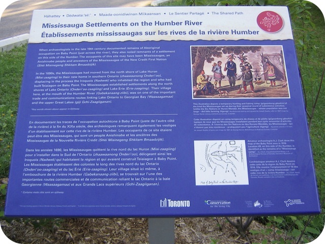
Mississauga Settlements on the Humber River
Photos by Alan L Brown - Posted August, 2011


This Story Circle, the thirteenth of 13 story circles on the "Discovery Walks - The Shared Path", can be found on the west side of the Humber River on Home Smith Park Road, 355 m from Old Mill Road. Here's what the plaques say:
Coordinates: 43.651584 -79.499571 |
 |
When archaeologists in the late 19th century documented remains of Aboriginal occupation on Baby Point (just across the river), they also noted remnants of a settlement on this side of the Humber. The occupants of this site may have been Mississaugas, an Anishinaubeg people and ancestors of the Mississaugas of the New Credit First Nation.
In the 1690s, the Mississaugas had moved from the north shore of Lake Huron to their new home in southern Ontario, displacing in the process the Iroquois who inhabited the region and who had built Teiaiagon on Baby Point. The Mississaugas established settlements along the north shores of Lake Ontario and Lake Erie. Their village here, at the mouth of the Humber River, was on one of the important trade and communications routes linking Lake Ontario to Georgian Bay and the upper Great Lakes.
Like other nations before them, the Mississaugas negotiated to their best advantage with the French and British governments who were competing to profit from this area. In August 1759, a few days after the British defeated the French for control of Lake Ontario, Tequakareigh, a leader from the Mississaugas village near the mouth of the Humber, negotiated peace with the British at Fort Niagara on the Niagara River.
The British eventually purchased from the Mississaugas much of the land now occupied by the City of Toronto - although some of the terms of that purchase were only finally settled in 2010. The Mississaugas continued to live in this area during the early years of the new Town of York, but then moved west in 1826 to settle at a mission under the leadership of Kahkewaquonaby (Reverend Peter Jones), near the mouth of the Credit River. In the 1840s, the Mississaugas were again under pressure to relocate. They accepted an offer from the Six Nations of the Grand River to settle on their reserve near Brantford, Ontario, where they have resided since 1847.
Shared Path Story Circles Information and Map
Discovery Walks - The Shared Path
Related webpages
The Humber River
archaeology
Mississaugas of the New Credit First Nation
Five Nations Iroquois
Teiaiagon
Fort Niagara
Credit River
Six Nations of the Grand River
Related Toronto plaques
Toronto Islands
Baby Point
Related Ontario plaque
Reverend Peter Jones 1802-1856
Links to all the other Story Circles
#1 Discover the Humber River's Ancient Past
#2 Toronto Carrying Place
#3 Railways Over the Humber
#4 Roads over the Humber River
#5 Boating on the Humber River
#6-1 The Beginnings of French Toronto
#6-2 The Rousseaux Family and Early Toronto
#6-3 Jean-Baptiste Rousseaux 1758-1812
#7 Humber River Marshes and Oak Savannah
#8 Huron-Wendat Villages on the Humber River
#9 Hurricane Hazel
#10 The King's Mill
#11 Teiaiagon and the Aboriginal Occupation of Baby Point
#12 Dundas Street Crossing and Lambton Mills
More
Rivers and Waterways
Here are the visitors' comments for this page.
(none yet)
Here's where you can sent me a comment for this page.
Note: Your email address will be posted at the end of your comment so others can respond to you unless you request otherwise.
Note: Comments are moderated. Yours will appear on this page within 24 hours (usually much sooner).
Note: As soon as I have posted your comment, a reply to your email will be sent informing you.
To send me your comment, click [email protected].
Thanks
Webmaster
Note: If you wish to send me a personal email, click here.