Discover Toronto's history as told through its plaques
2004 - Now in our 12th Year - 2016
To see what's new on this site, you can visit the Home Page
Looking at this page on a smartphone?
For best viewing, hold your phone in Landscape mode (Horizontal)
The Lost Village of Milton Mills
Photos and transcription by contributor Wayne Adam - Posted October, 2015


Photo Source - Toronto Public Library
On the north side of Old Mill Road, west of the bridge over the Humber River, can be found this set of 2013 Heritage Toronto plaques. Here's what they tell us:
Coordinates: 43.651236 -79.492565 |
 |
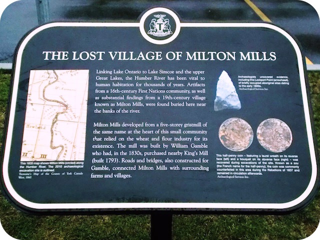
Linking Lake Ontario to Lake Simcoe and the upper Great Lakes, the Humber River has been vital to human habitation for thousands of years. Artifacts from a 16th-century First Nations community, as well as substantial findings from a 19th-century village known as Milton Mills, were found buried here near the banks of the river.
Milton Mills developed from a five-storey gristmill of the same name at the heart of this small community that relied on the wheat and flour industry for its existence. The mill was built by William Gamble who had, in the 1830s, purchased nearby King's Mill (built 1793). Roads and bridges, also constructed for Gamble, connected Milton Mills with surrounding farms and villages.
At its peak in the 1840s, Milton Mills was home to approximately 100 people. Many were Irish and English immigrants seeking work from the mill. Archaeological evidence shows that the mill supported local tradesmen, including coopers and blacksmiths. Archaeologists also found remnants of workers' cottages and of a tavern and inn for farmers travelling to sell their grain.
Repeal of the British Corn Laws in 1846 fundamentally altered Upper Canada's wheat and flour industry. Later, the development of railway networks eroded local markets. Many small mills and their related businesses were forced to close, including Milton Mills in 1865.
The remains of Milton Mills were part of 485 hectares of land purchased by Robert Home Smith in the early 20th century. Here, Smith developed a thriving residential neighbourhood known as The Kingsway.
Related webpages
gristmill
William Gamble
coopers
Corn Laws
Upper Canada
Robert Home Smith
The Kingsway
Related Toronto plaques
The Humber River
The King's Mill
Other Toronto plaques about mills
Early Don Mills
Early Mill Site
Gray Mill and Donalda Cattle Barn
Highland Creek Mills
The Old Mill
Silverthorn Family and Mill Farm
This Millstone
Todmorden Mills
York Mills
More
Pioneers
Here are the visitors' comments for this page.
(none yet)
Here's where you can sent me a comment for this page.
Note: Your email address will be posted at the end of your comment so others can respond to you unless you request otherwise.
Note: Comments are moderated. Yours will appear on this page within 24 hours (usually much sooner).
Note: As soon as I have posted your comment, a reply to your email will be sent informing you.
To send me your comment, click [email protected].
Thanks
Webmaster
Note: If you wish to send me a personal email, click here.