Discover Toronto's history as told through its plaques
2004 - Now in our 13th Year - 2017
To see what's new on this site, you can visit the Home Page
Looking at this page on a smartphone?
For best viewing, hold your phone in Landscape mode (Horizontal)
The Humber River
Photos by Alan L Brown - Posted November, 2013

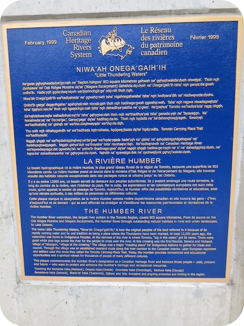
At the west end of the Bloor Street bridge over the Humber River, on the north side, can be found this 1999 Canadian Heritage Rivers System plaque. An identical plaque can be seen on the southeast corner of Dundas Street West and Old Dundas Street at the west end of the Dundas Street bridge over the Humber River. Here's what it says:
Coordinates: 43.649268 -79.494005 |
 |
The Humber River watershed, the largest river system in the Toronto region, covers 903 square kilometres. From its source on the Oak Ridges Moraine and Niagara Escarpment, the Humber flows through outstanding natural habitats in rural and urban landscapes, to Lake Ontario.
The name Little Thundering Waters, "Niwa'ah Onega'gaih'ih," is how the original peoples of the land referred to it because of its rapidly running water and by the oral tradition as being a place where the Thunderers have been marked. At least 12,000 years ago, the watershed was home to Indigenous Peoples. At the narrows of the river is where Toronto, "log in the water," got its name. There were great white pine logs across the river for the people to cross over the river. At this crossing was the Erie/Neutral, Seneca and Mohawk village of Taiaiagon, "village at the crossing." The village was a major "meeting place" for Indigenous Nations to gather for trade and council. Through the village was an established overland route along the river corridor to the Canadian interior. Later European explorers and settlers used this route they called the Toronto Carrying-Place Trail. Today, the Humber provides recreational and educational opportunities and a spiritual retreat for thousands of people of many different cultures.
This plaque commemorates the Humber River's designation as a Canadian Heritage River and honours those people - past, present and future - who want to protect and enhance the Humber's heritage and recreational resources.
Thanking the Kenienke haka (Mohawk), Oneota haka (Oneida) Onontaka haka (Onondaga), Kaokwa haka (Cayuga) Sonontowa haka (Seneca), Skaru-re haka (Tuscarora), Ojibwa and Erie Ancestral and ongoing protection protection and trading in the region.
Related web pages
The Humber River
Oak Ridges Moraine
Niagara Escarpment
Lake Ontario
Taiaiagon
Toronto Carrying-Place Trail
Canadian Heritage River
Mohawk
Oneida
Onondaga
Cayuga
Seneca
Tuscarora
Ojibwa
Related Toronto plaques
The Humber River
Humber River Marshes and Oak Savannah
The Toronto Carrying Place
Baby Point
Discovery Point
Étienne Brûlé
Samuel de Champlain's Journeys Through Ontario
Other Humber River plaques south of Dundas Street
Discovery Point
Discovery Walks - The Shared Path
Étienne Brûlé
The Humber River
Lambton House
The Old Mill
Samuel de Champlain's Journeys Through Ontario
Sir William Pearce Howland (1811-1907)
More
Rivers and Waterways
Here are the visitors' comments for this page.
(none yet)
Here's where you can sent me a comment for this page.
Note: Your email address will be posted at the end of your comment so others can respond to you unless you request otherwise.
Note: Comments are moderated. Yours will appear on this page within 24 hours (usually much sooner).
Note: As soon as I have posted your comment, a reply to your email will be sent informing you.
To send me your comment, click [email protected].
Thanks
Webmaster
Note: If you wish to send me a personal email, click here.