Discover Toronto's history as told through its plaques
2004 - Now in our 15th Year - 2019
To see what's new on this site, you can visit the Home Page
Looking at this page on a smartphone?
For best viewing, hold your phone in Landscape mode (Horizontal)
St. Andrew's Church
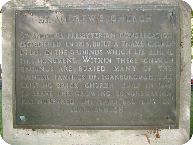
Photo by Alan L Brown - Posted October, 2006
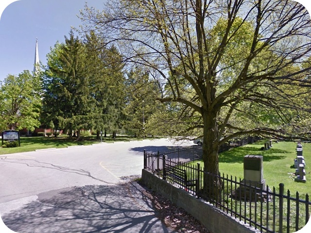
Photo from Google Street View ©2013 Google - Posted November, 2013
This plaque is located on St. Andrews Road in the cemetery of St. Andrew's Church (Scarborough) on a cairn erected by the Metropolitan Toronto and Region Conservation Authority is 1957. Here's what the plaque says:
Coordinates: 43.760260 -79.251659 |
 |
St. Andrew's Presbyterian congregation established in 1818, built a frame church in 1831 in the grounds which lie behind this monument. Within these church grounds are buried many of the pioneer families of Scarborough. The existing brick church built in 1849 to serve the growing congregation has nurtured the spiritual life of Scarborough.
Other plaques at this location
St. Andrew's Church
In Memory of David Thomson
Indian Trail
Scarboro' Centennial Memorial Library
The Thomson Settlement
Related webpage
St. Andrew's Presbyterian Church
Scarborough
Related Toronto plaque
The Thomson Settlement
More
Religious Buildings
Here are the visitors' comments for this page.
(none yet)
Here's where you can send me a comment for this page.
Note: Your email address will be posted at the end of your comment so others can respond to you unless you request otherwise.
Note: Comments are moderated. Yours will appear on this page within 24 hours (usually much sooner).
Note: As soon as I have posted your comment, a reply to your email will be sent informing you.
To send me your comment, click [email protected].
Thanks
Webmaster
Note: If you wish to send me a personal email, click here.