Discover Toronto's history as told through its plaques
2004 - Now in our 12th Year - 2016
To see what's new on this site, you can visit the Home Page
Looking at this page on a smartphone?
For best viewing, hold your phone in Landscape mode (Horizontal)
Paul Kane Park
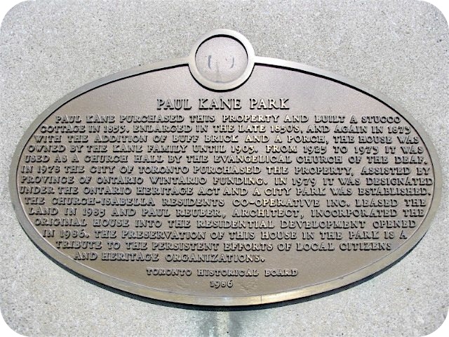
Photo by Alan L Brown - Posted September, 2006

Photo by Alan L Brown - Posted May, 2013
This 1986 Toronto Historical Board plaque on the south side of a cairn here at 56 Wellesley Street East, west of Church Street, has this to say:
Coordinates: 43.665683 -79.382154 |
 |
Paul Kane purchased this property and built a stucco cottage in 1853. Enlarged in the late 1850's, and again in 1873 with the addition of buff brick and a porch, the house was owned by the Kane family until 1903. From 1925 to 1973 it was used as a church hall by the Evangelical Church of the Deaf. In 1978 the City of Toronto purchased the property, assisted by Province of Ontario WINTARIO funding. In 1979 it was designated under the Ontario Heritage Act and a city park was established. The Church-Isabella Residents Co-operative Inc. leased the land in 1985 and Paul Reuber, Architect, incorporated the original house into the residential development opened in 1986. The preservation of this house in the park is a tribute to the persistent efforts of local citizens and heritage organizations.
Another plaque at this location
Paul Kane 1810-1871
Related webpages
Paul Kane
Ontario Heritage Act
Here are the visitors' comments for this page.
(none yet)
Here's where you can sent me a comment for this page.
Note: Your email address will be posted at the end of your comment so others can respond to you unless you request otherwise.
Note: Comments are moderated. Yours will appear on this page within 24 hours (usually much sooner).
Note: As soon as I have posted your comment, a reply to your email will be sent informing you.
To send me your comment, click [email protected].
Thanks
Webmaster
Note: If you wish to send me a personal email, click here.