Discover Toronto's history as told through its plaques
2004 - Now in our 14th Year - 2018
To see what's new on this site, you can visit the Home Page
Looking at this page on a smartphone?
For best viewing, hold your phone in Landscape mode (Horizontal)
Davenport Road - Ancient, Rural and Urban
Photos by contributor Wayne Adam - Posted August, 2011


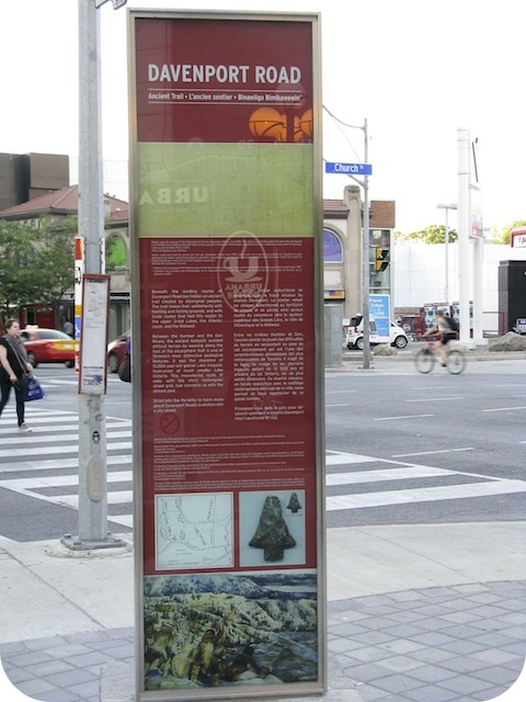
In a parkette on the southwest corner of Yonge Street and Davenport Road can be seen a set of three 2011 Heritage Toronto panels. The first, titled "Ancient Trail", has this to say:
Coordinates: 43.672722 -79.388001 |
 |
Beneath the winding course of Davenport Road lies hidden an ancient trail created by Aboriginal peoples. The trail linked their settlements with hunting and fishing grounds, and with trade routes that tied this region to the upper Great Lakes, the Atlantic coast, and the Midwest.
Between the Humber and Don Rivers, the ancient footpath avoided difficult terrain by weaving along the foot of the escarpment that is one of Toronto's most distinctive geological features. It was the shoreline of 13,500-year-old glacial Lake Iroquois, forerunner of much smaller Lake Ontario. This meandering route, at odds with the city's rectangular street grid, now connects us with the distant past.

Photos by contributor Wayne Adam - Posted August, 2011


The second, titled "Rural Road", has this to say:
The ancient trail beneath Davenport Road may have become known to Europeans in the 1600s when French traders, missionaries, and soldiers entered this area.
With the arrival of British settlers and the establishment in 1793 of the Town of York (now Toronto), the footpath was forever transformed. The trail through the forests allowed travel to and from newly settled lands, and was eventually widened to accommodate horses and wagons. The new road was named "Davenport" after a house built on the escarpment for John McGill in 1797.

Photo by contributor Wayne Adam - Posted August, 2011


The third, titled "Urban Street", has this to say:
As the forest along its length was cleared for farms and industry, the ancient trail beneath Davenport Road became an important link to small villages such as Yorkville and Carlton, and to the City of Toronto's markets. Beginning in the 1830s, the former Lake Iroquois deposits of gravel, clay, and sand were transported along Davenport Road for the building of the city.
Paved in one section with wooden planks in the mid-19th century, Davenport Road featured toll booths at its major intersections to finance the roadwork - one has survived at Bathurst Street, and is now a museum. By the 1890s, an electric street railway ran along Davenport west from Bathurst. Since the 1930s, increased automobile traffic has led to further widening of the road.
Created by ancient peoples, the Davenport Road route is today a busy urban thoroughfare.
Related webpages
Ice Age
Lake Iroquois
The Humber River
Don River
Town of York
Carleton Village
Related Toronto plaques
Davenport Road
The Escarpment
The Village of Yorkville
More
Transportation
Here are the visitors' comments for this page.
(none yet)
Here's where you can send me a comment for this page.
Note: Your email address will be posted at the end of your comment so others can respond to you unless you request otherwise.
Note: Comments are moderated. Yours will appear on this page within 24 hours (usually much sooner).
Note: As soon as I have posted your comment, a reply to your email will be sent informing you.
To send me your comment, click [email protected].
Thanks
Webmaster
Note: If you wish to send me a personal email, click here.